![](/images/other/stat-length.png)
![Randonnée Randonnée équestre Le Saint - Boucle courte - Photo](https://media.geolcdn.com/t/1900/400/ext.pjpeg?maxdim=2&url=https%3A%2F%2Fstatic1.geolcdn.com%2Fsiteimages%2Fupload%2Ffiles%2F1524743154cheval.jpg)
Boucle courte
Isabelle Pic
Utilisateur
![Longueur](/images/other/stat-length.png)
Longueur
13,7 km
![Altitude max](https://static1.geolcdn.com/siteimages/upload/files/1508320355ic_sort_altitude_max_24dp.png)
Altitude max
164 m
![Dénivelé positif](https://static1.geolcdn.com/siteimages/upload/files/1508320355ic_sort_den_pos_24dp.png)
Dénivelé positif
267 m
![Km-Effort](/images/other/stat-length.png)
Km-Effort
17,3 km
![Altitude min](https://static1.geolcdn.com/siteimages/upload/files/1508320355ic_sort_altitude_min_24dp.png)
Altitude min
81 m
![Dénivelé négatif](https://static1.geolcdn.com/siteimages/upload/files/1508320355ic_sort_den_neg_24dp.png)
Dénivelé négatif
267 m
![Boucle](https://static1.geolcdn.com/siteimages/upload/files/16400158638029165_repeat_loop_refresh_sync_direction_icon.png)
Boucle
Oui
Date de création :
2022-07-01 16:11:45.843
Dernière modification :
2022-07-01 16:14:51.208
![Randonnée équestre](https://static1.geolcdn.com/sitytour/trail-icons/301.png)
2h16
Difficulté : Facile
![Scannez ce code QR pour ouvrir la randonnée dans l'application SityTrail](https://capi.geolives.com/qq0zvz2zws4bq2lad0pu/sitytour/trails/3301037/qr.png?size=200)
Application GPS de randonnée GRATUITE
À propos
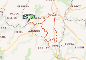
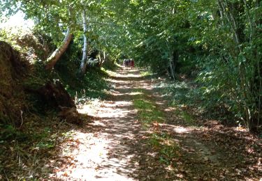
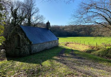
Randonnée Randonnée équestre de 13,7 km à découvrir à Bretagne, Morbihan, Le Saint. Cette randonnée est proposée par Isabelle Pic.
Description
Départ du DD Ranch Work pour une balade de 1/2 journée
Localisation
Pays :
France
Région :
Bretagne
Département/Province :
Morbihan
Commune :
Le Saint
Localité :
Unknown
Départ:(Dec)
Départ:(UTM)
455546 ; 5325588 (30U) N.
Commentaires
Randonnées à proximité
![Randonnée Marche Le Saint - LE SAINT - Photo](https://media.geolcdn.com/t/375/260/758b725a-51e6-4f52-9d84-85eb3bb1fa86.jpg&format=jpg&maxdim=2)
![Marche Marche](https://static1.geolcdn.com/sitytour/trail-icons/101.png)
LE SAINT
Marche
Difficile
(1)
Le Saint,
Bretagne,
Morbihan,
France
![](/images/other/stat-length.png)
23 km | 29 km-effort
5h 39min
![](https://static1.geolcdn.com/siteimages/upload/files/16400158638029165_repeat_loop_refresh_sync_direction_icon.png)
Oui
![Randonnée Randonnée équestre Le Saint - Guiscriff - Photo](https://media.geolcdn.com/t/375/260/ext.jpg?maxdim=2&url=https%3A%2F%2Fstatic1.geolcdn.com%2Fsiteimages%2Fupload%2Ffiles%2F1524743154cheval.jpg)
![Randonnée équestre Randonnée équestre](https://static1.geolcdn.com/sitytour/trail-icons/301.png)
Guiscriff
Randonnée équestre
Moyen
Le Saint,
Bretagne,
Morbihan,
France
![](/images/other/stat-length.png)
23 km | 28 km-effort
3h 38min
![](https://static1.geolcdn.com/siteimages/upload/files/16400158638029165_repeat_loop_refresh_sync_direction_icon.png)
Oui
![Randonnée Randonnée équestre Le Saint - Le Saint Langonnet - Photo](https://media.geolcdn.com/t/375/260/ext.jpg?maxdim=2&url=https%3A%2F%2Fstatic1.geolcdn.com%2Fsiteimages%2Fupload%2Ffiles%2F1524743154cheval.jpg)
![Randonnée équestre Randonnée équestre](https://static1.geolcdn.com/sitytour/trail-icons/301.png)
Le Saint Langonnet
Randonnée équestre
Difficile
Le Saint,
Bretagne,
Morbihan,
France
![](/images/other/stat-length.png)
30 km | 37 km-effort
4h 49min
![](https://static1.geolcdn.com/siteimages/upload/files/16400158638029165_repeat_loop_refresh_sync_direction_icon.png)
Oui
![Randonnée Randonnée équestre Le Saint - Le Saint Guircrif - Photo](https://media.geolcdn.com/t/375/260/ext.jpg?maxdim=2&url=https%3A%2F%2Fstatic1.geolcdn.com%2Fsiteimages%2Fupload%2Ffiles%2F1524743154cheval.jpg)
![Randonnée équestre Randonnée équestre](https://static1.geolcdn.com/sitytour/trail-icons/301.png)
Le Saint Guircrif
Randonnée équestre
Moyen
Le Saint,
Bretagne,
Morbihan,
France
![](/images/other/stat-length.png)
24 km | 28 km-effort
3h 44min
![](https://static1.geolcdn.com/siteimages/upload/files/16400158638029165_repeat_loop_refresh_sync_direction_icon.png)
Oui
![Randonnée Randonnée équestre Le Saint - Le Saint Gourin - Photo](https://media.geolcdn.com/t/375/260/ext.jpg?maxdim=2&url=https%3A%2F%2Fstatic1.geolcdn.com%2Fsiteimages%2Fupload%2Ffiles%2F1524743154cheval.jpg)
![Randonnée équestre Randonnée équestre](https://static1.geolcdn.com/sitytour/trail-icons/301.png)
Le Saint Gourin
Randonnée équestre
Moyen
Le Saint,
Bretagne,
Morbihan,
France
![](/images/other/stat-length.png)
25 km | 30 km-effort
3h 58min
![](https://static1.geolcdn.com/siteimages/upload/files/16400158638029165_repeat_loop_refresh_sync_direction_icon.png)
Oui
![Randonnée Marche Le Saint - Le saint - Photo](https://media.geolcdn.com/t/375/260/b0c05de9-010c-4408-97a4-d1b902cf250e.jpg&format=jpg&maxdim=2)
![Marche Marche](https://static1.geolcdn.com/sitytour/trail-icons/101.png)
![Randonnée sport Le Saint - 2024-05-07_14h08m48_visorando-circuit-equestre-du-domaine-de-tronjoly-modifie - Photo](https://media.geolcdn.com/t/375/260/ext.jpg?maxdim=2&url=https%3A%2F%2Fsecurestorage.geolives.com%2Fsitytour%2Ftrail-bg%2Fdefault.jpg)
2024-05-07_14h08m48_visorando-circuit-equestre-du-domaine-de-tronjoly-modifie
sport
Très facile
Le Saint,
Bretagne,
Morbihan,
France
![](/images/other/stat-length.png)
24 km | 29 km-effort
Inconnu
![](https://static1.geolcdn.com/siteimages/upload/files/16400158638029165_repeat_loop_refresh_sync_direction_icon.png)
Oui
![Randonnée Randonnée équestre Le Saint - gourin le roi Morvan - Photo](https://media.geolcdn.com/t/375/260/ext.jpg?maxdim=2&url=https%3A%2F%2Fstatic1.geolcdn.com%2Fsiteimages%2Fupload%2Ffiles%2F1524743154cheval.jpg)
![Randonnée équestre Randonnée équestre](https://static1.geolcdn.com/sitytour/trail-icons/301.png)
gourin le roi Morvan
Randonnée équestre
Difficile
Le Saint,
Bretagne,
Morbihan,
France
![](/images/other/stat-length.png)
28 km | 33 km-effort
7h 18min
![](https://static1.geolcdn.com/siteimages/upload/files/16400158638029165_repeat_loop_refresh_sync_direction_icon.png)
Non
![Randonnée Randonnée équestre Le Saint - Le Saint - Photo](https://media.geolcdn.com/t/375/260/ext.jpg?maxdim=2&url=https%3A%2F%2Fstatic1.geolcdn.com%2Fsiteimages%2Fupload%2Ffiles%2F1524743154cheval.jpg)
![Randonnée équestre Randonnée équestre](https://static1.geolcdn.com/sitytour/trail-icons/301.png)
Le Saint
Randonnée équestre
Moyen
(1)
Le Saint,
Bretagne,
Morbihan,
France
![](/images/other/stat-length.png)
21 km | 26 km-effort
3h 27min
![](https://static1.geolcdn.com/siteimages/upload/files/16400158638029165_repeat_loop_refresh_sync_direction_icon.png)
Oui